In-house Training
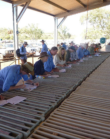
Whilst we have developed the series of training modules listed below as a guide, in practice module topics are adapted to suit specific problems within the local geology, the existing level of training of the participants, and the amount of time available. A common scenario would be 2-4 hours of early morning theory discussion followed by mine, field, or core shed examination of specific problematic areas within the project by the participants. This gives us a chance to see how the local geologist is looking at his problem, and allows demonstration and group discussion of practical approaches to the problem. Then back to the classroom for a wrap up theory/discussion session on what we have seen and done. Generally the minimum on-site time that you need to consider for this approach to be worthwhile is 4 days depending on the scope of topics required.
-
Basic courses lay down a foundation of structural tools or geochemical tools common to all terrane types
-
More advanced structure courses focus on the separate field and cross-section requirements of thin-skinned fold-thrust terranes and metamorphic/ basement terranes
-
Geochemical courses & workshops concentrate on developing the links between observation and practical analysis

HCOV Global Training Modules
The model courses contain sets of related modules. In practice, courses are tailored to suit the clients needs and the local terrane type. Training is most effective when courses are delivered in-house and on-site.
1) Elementary Field Skills modules Entry-level modules tailored for geological staff whose professional background training has been very weak. Includes basic training to recognise and correctly measure bedding; to understand and use combined structural and topographic information; to construct and interpret basic geological maps; and to construct basic cross-sections from field data.
2) Underground and pit mapping modules Basic tools and skills required to produce effective underground or pit geological maps. The course concentrates on providing maps that maximise the data available. The emphasis can be on either structural mapping or alteration mapping, or both.
3) Basic structure modules Basic structural geology modules common to all terrane types and situations plus sufficient theoretical background to handle anomalous structures. Includes oriented drill-core procedures, with both stereographic and computer processing of results… Aimed at providing refresher courses for geological staff whose structural memory is rusty.
4) Intermediate structure modules Structural geology tools and skills specific to moderately deformed terranes from low to high grade metamorphic rocks. Includes recognizing and measuring primary and metamorphic fabrics; folds; bedding facing and vergence; and selecting appropriate cross-section techniques from the range available; fault geometry and kinematics; using and interpreting stereographic projections; 3-D modeling constraints.
Where appropriate can also include topics specific to thin-skinned fold-thrust terranes: geometry of thrust-related folds; recognition of detachment surfaces; linked fault and relay (accommodation) geometries; the gathering and use of fault kinematic data; …
5) Alteration workshop/ mapping course Workshop/on-site course designed to raise skills in recognising, sampling, and mapping alteration patterns. The mapping component focusses on developing useful maps of alteration patterns in a mine or pit context. The workshop is based around using both our ‘best example’ rocks, and your project rocks to recognise and distinguish different patterns of veining, alteration and lithological controls on mineralisation. The emphasis can be on either (or both) mapping practices or on recognition and sampling as a prelude to analysis.
6) Large hydrothermal systems workshops Three workshop-style modules aimed at improving your capacity to recognise fluid conduits and their metal-carrying or precipitating capacity, turning this into a revised from hand specimens is the focus of link to Module A. You are shown how to turn this into a revised sampling strategy or methodology, or recognition of specific needs for geochemical work. Basic principles of what to do with geochemical data in conjunction with these rock observations is the focus of the second module link to Module B. Finally, placing all these observations into the structural context, allows you to connect your spatial/structural and geophysical datasets to the alteration observations and geochemical datasets, as demonstrated in Module C.
7) Advanced structural analysis Tools, skills and theoretical background required to interpret multiply deformed complex structures and shear zones in metamorphic rocks of all grades. Aimed at training geologists working in complex terranes, particularly in metamorphic rocks, or providing in-depth background for procuring, evaluating, and understanding the output of structural specialists and consultants in such terranes.
8) Field mapping modules 5-7 day guided field mapping programs aimed at developing mapping and interpretation expertise at either project scale (~1:5000) or at district scale (~1;50000). The former are generally run on-site; the latter are commonly run in moderately complex areas that are economically accessible to the client and have a level of geology and outcrop that is conducive to such training. We have arranged courses of this type in western Thailand; Mount Isa, Australia; southern Turkey; Guinea; and the DRC.
9) Structural interpretation of aeromagnetic data. A hands-on workshop designed to introduce participants to the principles and techniques required in order to carry out geologically rigorous interpretation of aeromagnetic and radiometric datasets in geologically complex areas. Topics covered include the basics of the aeromagnetic and radiometric methds; understanding of collection and processing of data; sources of magnetic and radiometric signatures in rocks; and numerous worked exaples illustrating a practical approach to the production of solid geology interpretations and associated 2D and 3D structural analyses.
